Archive for the ‘Asia’ Category

Zhangye to Xining — Northeast Corner of Tibet

Monday, October 20th, 2014

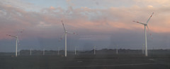
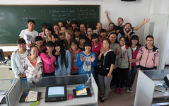
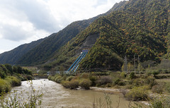
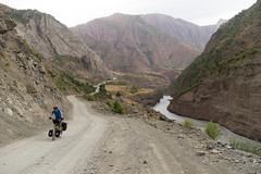
After the bikes decided they’d had enough of independent travel and showed up in Zhangye (see our last entry on waiting for our bikes to arrive), we enjoyed a last evening with our friends and left town the next morning. Soon we were in a rural area where the street was lined with cornfields ready for harvest. For most of the day we followed the Liyuan River, and every half hour or so we passed a run of the river hydroelectric facility. I don’t think I’d ever seen such a hard working river. In between there were stretches that seemed free flowing, but then we’d encounter a small reservoir or pipe carrying water down from higher elevations. I’d like to learn more about this technology. It’s not new, but I don’t think I’ve ever seen it in the U.S. I’m curious about the environmental impact and cost per unit of energy generated, because at first glance it seems much less disruptive than the large dams and reservoirs I’m used to seeing.

China 4 - Tibet 1 - To Xining

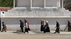
In the afternoon, we started passing signs for the ‘Chinese Yugur Amorous Corridor’ (We assumed they meant ‘autonomous’ and not ‘amorous,’ although we were ready to be proved wrong). Paintings, statues, and banners along the road indicated that we were in a unique part of China. Shortly before sunset we found ourselves in the town of Sunan and decided to treat ourselves to a hotel, where we did some reading and learned that the Yugur people, rather than being particularly amorous, are in fact an ethnic group with their own autonomous county. According to Wikipedia, the Yugurs are descended from a group of Uyghurs (the most prevalent ethnic group in Xinjiang) that fled from Mongolia after the Uyghur Empire collapsed. The community around Sunan is Buddhist and speak a Turkic language. Sunan was a pleasant surprise – the Liyuan River runs through the town, and a riverside park is full of statues, people strolling in the evening, and neon lights illuminating the bridges after dark. We splurged on a hotel room for $20.

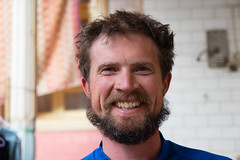
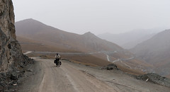
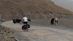
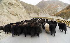
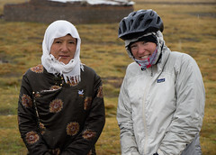
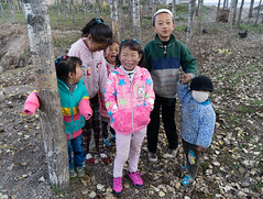
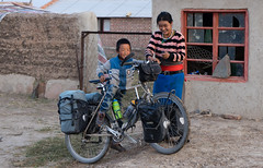
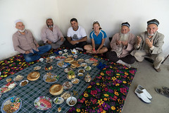
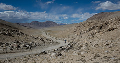
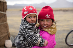
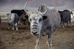
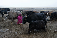
The next morning, just a few kilometers out of Sunan, the road turned to dirt and started climbing to the first pass of this leg of the journey. As we climbed, it got colder and we started encountering herds of yaks. Tibetan yaks are slightly different from the ones we saw in Tajikistan and Kyrgyzstan – slightly shaggier and, in my opinion, a little bit cuter. We were grateful for the extra clothes we’d bought at the night market in Zhangye. A while before sunset we came upon a series of what we think were mining camps. A Chinese cyclist we’d met in Kyrgyzstan had written a note in Chinese asking for a place to camp, and we showed it to a woman at one of the camps. She knew exactly what we needed, but instead of having us pitch our tent, they let us sleep in one of the small pre-fab buildings that lined the roads. They also made us dinner; at that point we had just learned how to say ‘want’ (‘yao’) and ‘have’ (‘you’) and we got them mixed up. Luckily, our language difficulties meant that one of the women cheerfully whipped up some egg and onion and we ate that with rice – much better than the instant noodles on the menu. We hung out with them all evening and practiced our Putonghua, and they taught us to count to 10. These were the first Chinese people we had actually spent time with since arriving in the country, and as I’ve noticed each time I cross a border, that first experience helps me feel a bit more welcome and at home in a country.

China 4 - Tibet 1 - To Xining

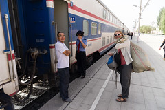
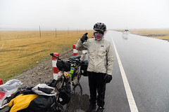
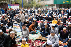
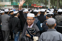
When we woke up, a light snow was falling and our new friends were worried about us, but we figured we could make it to the pass and get down to a lower elevation where it would be more comfortable. We were right, but the descent was extremely cold and our hands and feet kept freezing and we had to stop and do jumping jacks to warm ourselves up. On the other side, we found ourselves back in a Muslim town, and we stopped at a noodle shop for lunch. Everybody in the restaurant was curious about us and greeted us warmly before finishing their lunches and leaving. We ordered lunch, with the help of an app that screens characters and translates them, and we took pictures with the cheerful owners. However, before our food even arrived, two police officers came into the restaurant and sat down at our table. They didn’t speak much English, so one left and returned with the town’s English teacher. She delivered the bad news: we were in an area forbidden to foreigners and we must leave right away. They were quite nice about it, and we nodded our heads agreeably, scarfed our lunches, and left. We had asked them where exactly the ‘forbidden’ area was, but even with a map we couldn’t get a clear answer. So we decided to lay low as much as we could, meaning no attempts to stay in hotels or eat at restaurants, and a rushed trip into the next grocery store we encountered in order to stock up on food for the next few days. We also wore our buffs pulled up over our faces so nobody would guess we were foreigners. (We totally blended in.)

China 4 - Tibet 1 - To Xining

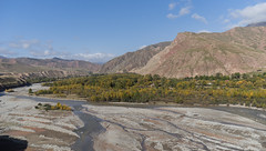
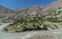
We rode out of town and into a canyon along the Heihe River, a tributary to the Yellow River. Leaves were starting to turn and yellow trees lined the river. Canyons are difficult to camp in, especially when you’re trying to hide, but eventually we found a spot, right before sunset, where we were hidden from the road. As we biked out of the river canyon the next day, we passed farms where people were cutting hay and stacking it in neat pyramids to dry. There must have been wild mint growing amid the hay, because the whole valley smelled fresh and delicious. It’s interesting to see how different places go about their farm work; in most of eastern Europe, hay was tossed onto a sharp stake sticking out of the ground, making Van Gogh-like haystacks. In the U.S., we bale it. In Tajikistan and Kyrgyzstan we saw it tossed onto roofs. In this part of China, it was gathered into bundles the width of a telephone pole, tied with another handful of hay, and propped up against another bundle in an upside down V. These V’s are arranged in rows supporting each other so the fields are dotted with what look like pup tents made out of hay.

China 4 - Tibet 1 - To Xining

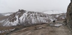
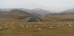
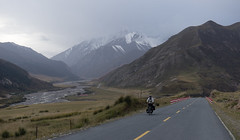
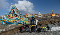
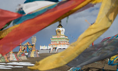
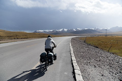
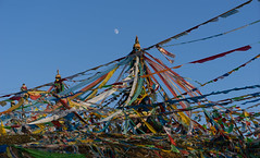
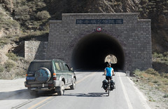
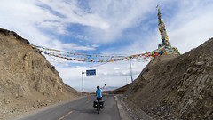
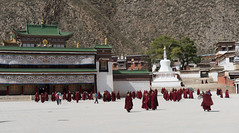
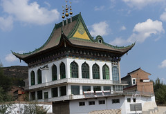
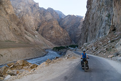
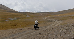
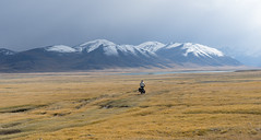
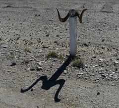
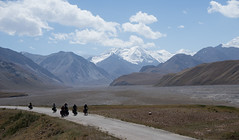
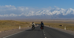
We passed through Qilian in the late morning, wearing our ‘disguises’ and racing through the town in case we were still forbidden. In the middle of town we turned right, heading towards the mountain range we’d been paralleling all day. The road went up and up in a series of glorious switchbacks. We’d been climbing steadily since the day before, but it was well-graded and we made good progress. We reached the pass in the late afternoon and that was when we knew we were in Tibet. Prayer flags fluttered in rows up to a Chorten (stupa), and bundles of arrows (piercing through ignorance, I think) were plunged into the ground, with more prayer flags stretched between them. Incense was burning and prayer paper littered the ground. Groups of tourists, having been driven to the top, were posing next to a sign made in astroturf with the pass’s elevation – 4120m. We took the obligatory pictures and enjoyed the view, then headed down the other side.

China 4 - Tibet 1 - To Xining

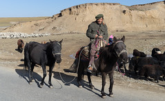
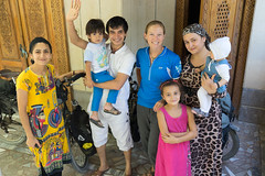
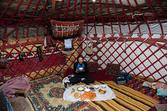
Shortly before sunset we started looking for a place to camp but ran into a bit of a problem: In China, we’ve encountered a lot of barbed wire fencing, something we really haven’t seen anywhere else on this trip. We’ve been told and read that the government has been requiring the Tibetan nomads to settle, and in exchange for giving up their traditional lifestyle, the government provides a house and plot of land where they are expected to graze their animals. So it was difficult to find an accessible place to pitch our tent, and eventually we turned onto a side road and asked people we encountered if we could camp. This time, the note didn’t work at all – these people were Tibetan and spoke Amdo; like us, they couldn’t read Mandarin. So we resorted to hand signals, and a lovely couple in a tent that doubled as a store motioned to the land outside their tent where a flock of sheep were bedding down for the night. Before we even opened our panniers, though, they motioned for us to follow them across the road, where they unlocked one of the standard government houses and ushered us inside. From what we could tell, this was their house but they prefer the tent. It had three rooms and they let us stay in the main room where there was a wood stove and a kang, or raised platform where mats are rolled out in the evening for sleeping. They started a fire and gave us water to make dinner. In another room, there was what looked like a shrine, along with a sound system with big speakers (we’ve since seen this in all the Tibetan homes in the area) and a photo of Mao. Interesting.

China 4 - Tibet 1 - To Xining

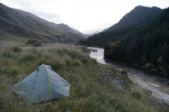
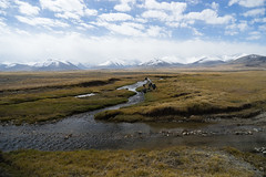
We stayed with another family the following night, although under slightly different circumstances. We had crossed another, lower pass, and as we descended we noticed that we weren’t crossing any streams – the ground was wet and boggy, with muddy pools and no running water. It seemed to all seep into the ground as it ran down from the mountains. It was getting late, so we stopped to ask for water at a house off the road where an old Tibetan lady was standing outside. She smiled and invited us inside, where she and her daughter served us tea and fried bread. We thanked them and asked for water to cook with, and they offered hot water from a kettle – as we’ve since discovered, cold water isn’t really a thing in China (people are surprised that we want to drink cold water). At this point it was getting late enough that we needed to find a place to sleep soon, so we tried asking if we could camp. The note written in Chinese didn’t work, so we showed them a picture of our tent. They seemed to understand but we couldn’t quite tell if they’d given the OK, and then things got confusing. We went outside for a moment, and suddenly the older woman followed us out with the few items we’d brought inside, dumped them on the ground next to our bikes, and motioned for us to leave.

We’re not sure what was going on – the phone had rung a couple times while we were there, and a neighbor had come over, and we think somebody told them not to associate with us. We don’t know if we were still ‘forbidden’ there, but it’s possible that if they had been found with us in their house, they could have gotten in trouble. We felt awful for possibly putting them in that position, but also confused because they’d been so welcoming at first and invited us in when all we wanted was water. We were now in quite a bind because the sun had just set and we had no water and nowhere to sleep and didn’t feel like we should ask other people in the area for help. Plus, a storm was coming up behind us. So we rode on, hoping to find water and a spare patch of ground before the rain started. We’d biked about 15 minutes when a car pulled over just ahead of us. We stopped and when the man opened his door we asked about water. Without hesitation he poured the contents of his thermos into David’s water bottle. Half a liter of tea was nice but it wouldn’t get us very far… He was clearly worried about us and told us the next town was 40km away and that we should tie our bikes to the roof and get a ride with him. We thanked him but it would have been impossible, and we explained in our best Putonghua that we had a tent and just needed water. He thought for a minute and then pointed to a house down the road and motioned for us to follow him. He sped off and we almost lost him, but were able to follow him down a side road. By the time we got there he had a thermos in hand and was talking to the family.

China 4 - Tibet 1 - To Xining

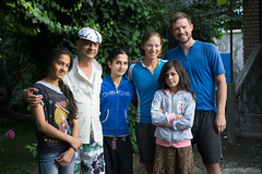
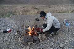
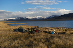
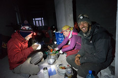
Since we had a friendly translator, we showed him the note and he asked the family if we could camp there – we hoped that if it was risky for them they would say no. Instead, they readily agreed, and then we were able to have them talk to our friend on the phone, who told them that we had food and a tent and just needed cold water for cooking and a place to camp. After everything was fairly clear, our translator-friend left and the family invited us to sit down next to the fire. They served us a variation of tsampa (barley flour mixed with yak butter) and gave us hot water for our instant noodles. Then, they led us outside to their ‘guest yurt’ – a small canvas tent in the pasture, with a raised sleeping platform in the middle. As it was cold and gusty and still threatening rain, we were grateful to not have to set our tent up.

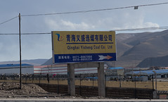
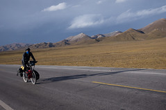
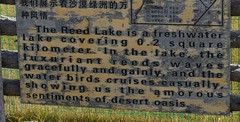
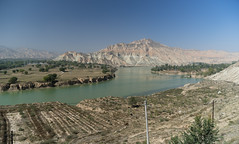
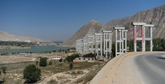
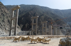
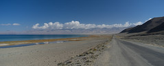
We woke up to snow and took our time getting ready, hoping it would let up. It showed no signs of stopping, thought, so eventually we forced ourselves to get up, say goodbye to our hosts, and ride into the snow. It kept up for a couple of hours, turning into rain as we descended to lower elevations, and all in all it was among the more miserable biking of the trip. Shortly before noon, though, the rain stopped and we were biking under blue skies. That afternoon, we passed by several coal mining or processing operations – trucks full of coal were coming and going and we could see some machinery, but most sites had tall blue fencing around them blocking a full view. In the afternoon, we were faced with a decision: continue on the same road, which was getting busier as we got closer to Xining, or take a slightly longer route on back roads past Qinghai Lake, the largest saltwater lake in China. You can probably guess which route we chose.

China 4 - Tibet 1 - To Xining

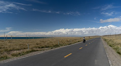
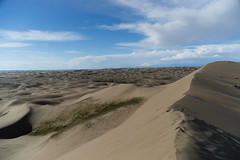
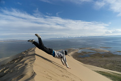
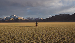
The back road was quiet, with only the occasional passing car, and before long we could see the lake on our right. We decided to be proper tourists and visit the Sand Island Scenic Area. We were pleasantly surprised – they let us ride our bikes out through the dunes to the lake, on paths lined with large sculptures made as part of an art festival hosted there. The lake itself was gorgeous – deep blue with a backdrop of snowcapped mountains reminiscent of Zorkul in Tajikistan – but the real highlight was the dune diving. We walked to the top of a dune and did our best to defy gravity. I think we’ve finally gotten all the sand out of our hair, ears and pockets… Of course we lingered too long, and by the time we left the park it was approaching sunset and another storm was brewing. We biked just a short distance until we came upon a cluster of abandoned buildings between the road and railroad tracks. They were surprisingly clean, and we enjoyed another night where we could cook under a roof and not have to set up the tent.

China 4 - Tibet 1 - To Xining

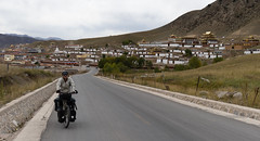
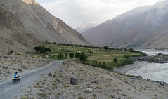
The next day was clear, and we focused on the remaining 130 km to Xining. It turned out to be a lovely ride, since a new expressway meant we could ride on the old highway with relatively little car traffic. First, we encountered dozens of Chinese tourists biking a circuit around Qinghai Lake. It was the first day of Golden Week, the national holiday, and everybody was on vacation. Then we continued on, following a river downstream nearly all the way. After a week at elevation, we were back in a milder climate and the beginning of fall. The hillsides on either side of the river were dotted with yellows, orange and red, and we could see pagodas on some of the hilltops. I felt like we were biking through a Chinese version of Vermont and it made me both homesick and content to be just where I was at that moment.

China 4 - Tibet 1 - To Xining

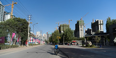
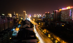
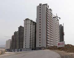
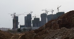
As we approached Xining, the road went through a series of industrial towns and the riding got less enjoyable. The air was full of dust and the roads were suddenly choked with large trucks, honking incessantly. We have a number of theories about honking behavior in China – are drivers taught to honk as a safety measure whenever other people or vehicles (or bikes) are around, just so we know they’re there? Did they not learn that they need to share the road, and they’re warning us to get out of their way? Trucks rarely slow down in populated areas – they just lean on the horn and barrel through. After awhile, the industrial towns gave way to what looked like entire brand new cities being built on the outskirts of Xining. Clusters of identical skyscrapers lined both sides of the roads, with cranes hovering above them, building away. According to one of the city’s residents, Xining’s population has quadrupled in the last decade, yet the new buildings don’t have tenants – they’re just standing empty. It was an odd feeling to so abruptly transition from grasslands and Tibetan nomads, to chaotic industrial towns, to empty tower blocks, and finally to Xining itself.

China 4 - Tibet 1 - To Xining

One Month in China: Photos

Thursday, October 16th, 2014

Below are our best pictures from our first month in China. You can also see more photos on our flicker page by clicking on these links:
Kashgar
Kashgar to Zhangye by Train
Zhangye
Zhangye to Xining
Xining to Lanzhou

Leg 1 in China: Kashgar to Zhangye by Train

Friday, October 3rd, 2014

We arrived in Kashgar in the early evening after our mandatory taxi ride between border posts. ‘Early evening’ is a confusing concept in far western China; the whole country, which is as wide east-to-west as the US, operates on Beijing time. So in early September, the sun doesn’t set in Kashgar until after 9:00 pm, and it doesn’t rise until after 8:00 am. We struggled to adjust to the time difference, but since parts of Xinjiang Province operate on their own informal time zone (two hours behind Beijing, the same as Kyrgyzstan and eastern Tajikistan), it didn’t matter too much.

Kashgar

We spent our first day recuperating and bingeing on internet and good food. After weeks in the sparsely populated Pamir Plateau, we were overwhelmed by all the people, commerce, and food. We had heard a rumor that train tickets were sold out for several days due to a mysterious Chinese holiday (later we were told that it was mid-autumn festival), so we didn’t rush to the station. We also hadn’t decided yet where to go. After one day of studying the map, we decided to take the train to Zhangye, in Gansu Province, and then bike over the Qilian Mountains to Xining on the northern edge of the Tibetan Plateau. Then we would bike another scenic (aka indirect) route to Lanzhou, staying on the Plateau as long as possible. However, when we made it to the station, we were told there were no tickets available for another five days. We quickly consulted our calendars and decided that we could make it work.

Kashgar

So we secured our tickets and set about visiting some Kashgar sites. First was the weekly animal market – I have never seen so many fat-tailed sheep in one place and frankly, it was a little disturbing. Some animals are slaughtered on site, and we watched a sheep being reduced to cuts of meat from a whole animal in minutes. Later, we saw the same procedure on our street – one animal would be hanging, in pieces, for people to buy, and a live sheep would be tied up nearby. When the last hunk of meat was sold, the waiting animal would be butchered on the spot. I had a lot of conflicting feelings about this – at home I rarely eat meat, for a lot of reasons. Here, I eat whatever people feed me, which often includes meat, for another tangle of reasons. On the one hand, I appreciate the apparent closeness between people and their animals. It isn’t sentimental, but somehow it seems slightly more humane to cut an animals’ throat by hand on the day it will get eaten – and probably within a few kilometers of the dinner table – than to round animals up and ship them off to anonymous slaughterhouses. I don’t know the environmental impacts of all the grazing we see, but I’m guessing it’s better for the animals, us, and possibly the land than factory farming. However, there is still suffering, and it still feels fundamentally wrong to kill another being just so I can eat it, when generally there are plenty of viable alternatives. In some of the places we’ve traveled, though, there really aren’t, and for herders, I imagine this is the most sensible and economical way to get their meals.

Kashgar

After the animal market, we visited the Sunday bazaar, and on the walk back we wandered through part of the old walled city. At first it appeared deserted, but after climbing some steps between the houses, we found a vibrant neighborhood, though it looks like it may be slated for destruction. There were weird big spotlights all around the walled area and it looked like a park was being developed nearby.

Kashgar

We went to the night market several times for dinner – you can just wander from stall to stall and have a little bit of everything: steamed dumplings, kebabs, goat’s head soup (we didn’t have it, but another person from the hostel tried it. He said it was delicious, but I can’t bring myself to eat a part of an animal that makes expressions; you’ve gotta draw the line somewhere…), noodles with chickpeas, hot pot, plov, and multiple servings of ice cream to put out the fire and feed our addiction, which had been neglected in the ‘stans. After our first night we observed that we’d just had more variety in one meal than we’d had in three weeks in the Pamirs. It’s not that the food there was bad, just simple, and sparse.

Kashgar

Partway through our time in Kashgar, I got sick and spent a couple of days lying in our hotel room. While it was a bummer not to feel well (especially with all the delicious food in the city), in some ways it was nice to have an excuse to do nothing. I Skyped with family and friends, caught up on the news (and Facebook), read books about China, and generally lazed around. The day before our scheduled departure, we took our bikes to the train station to be sent ahead as cargo, following the advice of other bike tourists and the hostel staff who said that this was standard protocol and that the bikes would arrive at the same time as we would, or even before.

Train to Zhangye

Finally, it was time to leave Kashgar, and we took a taxi to the station. Boarding the train was a smooth process, and we quickly settled into our ‘hard sleeper’ bunks. One of the interesting things about the train was the ethnic distribution across the different seating classes. The hard sleeper class consists of four or six bunks to a compartment – quite comfortable, if a bit cramped. Most of the other people in the sleeper cars were Han Chinese (China’s ethnic majority), although the train was traveling through Xinjiang Province, which has a very large Uyghur population (one of China’s many ethnic minorities). While wandering around the train I eventually stumbled upon the ‘hard seat’ section, and it was a sudden explosion of color and sound – nearly all of the passengers in this class were Uyghur, and colorful headscarves, embroidered skullcaps, and friendly waves and smiles suddenly surrounded me. A group of men invited me to sit on the floor with them, and we had a stilted conversation in Turkik-ish.

Train to Zhangye

In the middle of the night, the train stopped at a station and didn’t move for eight hours, which meant that we would miss our connecting train in Urumqi. David befriended a Chinese woman who spoke some English, and she walked us through the process of changing our tickets once we arrived in Urumqi, sometime after midnight on the second day. She also tried to help us find a hotel near the train station, but the one she showed us to refused to let us stay (there are strange rules about which hotels can accept foreigners). Since it was nearing 2:00 AM and our train left at 9:00 AM the next morning, we decided to just go with brand recognition and we struck out to the Super 8 that we could see across the freeway from the train station. However, the road system was so convoluted that we had to take a taxi there. The driver tried to convince us to let him take us to another place that was allegedly cheaper (but would require a higher taxi fare), but we refused since we had no idea where he wanted to take us. We soon regretted our decision, though, when the Super 8 was full (the girl sleeping on a cot behind the desk woke up for long enough to wave her hands in front of her face – a clear “no!”). A lap around the nearby hotels yielded the same results. At this point it was nearly 3:00 AM. Getting back to the knot of taxi drivers who had fought over us earlier in order to have them take us to the mysterious ‘cheaper’ place didn’t really appeal, and at this point we wouldn’t get more than five hours of sleep wherever we went. So we did the logical thing, which was to take the elevator in the Super 8 up a few floors until we found a nice carpeted alcove. There, between the fire escape and a convenient door that hid us from the hallway, we bunked down for the remainder of the night. Despite a high-pitched beep emanating from above our heads every couple of minutes and a moment of panic when I heard voices and thought we’d be discovered, we slept quite well and were refreshed for the next leg of our train trip.

Train to Zhangye

We finally arrived at our destination, Zhangye, a ‘small’ town of about one million in the Hexi Corridor (a narrow strip of land between mountain ranges where the Silk Road routes converge) shortly before midnight on the third day of travel. Our bikes were nowhere to be found, but we figured the cargo office just wasn’t open at that time and that we could get them the next day. Fortunately, we had lined up a place to stay with a Peace Corps volunteer, and soon we were comfortably bunked down in his spare room. The next day we ventured back to the train station where, after some charades, google translate, and finally a call to our Beijing Hero, Alvin (a friend of a friend who has helped us out a ton), we learned that the bikes had been sent with a different company and we needed to call a number or visit an address on the receipt. Our host, Raines, enlisted a student to call the number, and we were both devastated and relieved to learn that they had been sent past Zhangye to Lanzhou, the provincial capital, for ‘security inspection’ and that they would arrive two days later. We were relieved because at least they hadn’t been lost, but we were frustrated since the combination of train ticket availability and bike delay meant that we probably wouldn’t be able to make it to Mongolia in the time left on our multiple-entry visa (we have a year-long visa but we can only stay for 30 days at a time). We’re still figuring out how to handle that.

We made the best of our time, though – we had lots of tasty meals with Raines and Kelly, another volunteer, as well as some other teachers and students. We also visited their classes and gave a presentation on our trip, and saw the giant Buddha for which Zhangye is famous. It was a beautiful site and we enjoyed wandering the temple and the surrounding part of the city. Zhangye is a nice, manageable size and there is plenty of delicious food near the university, and with our excellent hosts we felt like we’d had a soft landing into central China. When the bikes finally arrived (three days or two hours behind schedule, depending on how you look at it), it was too late to start biking, so we enjoyed a last night with our fellow Americans – we watched Frozen and I baked ‘cookies’ with the odds and ends I could find in the supermarket (buckwheat oatmeal chocolate bar chunk cookies, anyone?) and Kelly’s baking supplies, which fortunately included baking soda and cinnamon – all you need, really.

Zhangye

Zhangye

Zhangye

The next morning we started our first real biking in China – stay tuned for a post on biking up and around the Tibetan Plateau in Qinghai Province!

Pictures from Tajikistan and Kyrgyzstan

Monday, September 15th, 2014

The past month of riding has been the most spectacular of the trip: numerous mountains rising more than 6,000 meters (20,000ft), lonely dirt roads, yurt camps, mountain rivers, deep canyons, and high passes. We took a lot of pictures.

Rather than post them all here, I’m only posting the very best pictures below, and then including links to albums with more pictures.

And click on any of the images below for albums with more images:

The Border to Dushanbe
Tajikistan - The Border to Dushanbe

To Khorog, Part I
To Khorog, Part I

To Khorog, Part II – Along the Afghan Border
To Khorog, Part II - Along Afghan Border

The Wakhan Valley
Wakhan Valley

The Pamirs, Part I – To Zorkul Nature Reserve
The Pamirs, Part 1: To Zorkul Nature Reserve

The Pamirs, Part II – Murghab to the Border
The Pamirs, Part II: Murghab to the Border

To Kyrgyzstan with the Kyzyl-Art Schmutzig Singers

The Wakhan Valley, the Pamir Plateau, and a Corner of Kyrgyzstan

Sunday, September 14th, 2014

I am writing this from a “hotel” at the border between China and Kyrgyzstan, where Lindsey and I are staying for $4 each, and for which I think we probably overpaid. There is no running water (or Internet), and the bathroom is a row of squat toilets behind a brick wall. We were forced to stay here because China forbids (apparently a new rule) people to travel independently for the first 140 kilometers on the road to Kashgar (“It is not allowed”), so we have to get a taxi to cover this distance. However, we arrived at the border in the late afternoon, after the last taxi had left. The border guards would not let us hitch a ride on a truck, and instead told us we had to wait until the next day. So we are at this hotel.

We’re using this break between Central Asia and China to write about the past three weeks of biking, which have been the most remote, challenging, and beautiful of the entire trip. This leg included fierce headwinds with snow, a night in a yurt, and empty valleys where we followed jeep tracks and saw a herd of Marco Polo Sheep, almost the entire time cycling above 10,000 feet in elevation.

Lindsey and I are team writing this post, as it is broken down into a few sections of travel.

The Wakhan Valley

by David

If you look at a map of Afghanistan, you’ll see a tongue sticking out of the northeast part of the country, separating Tajikistan from Pakistan. The Afghan-Pakistan border follows the peaks of the Hindu Kush mountains along the southern edge of the tongue, while Afghanistan’s border with Tajikistan, on the northern edge of the tongue, is formed by the Panj and Pamir Rivers. In some places, Afghanistan is only a few miles wide.

This strange geography is a product of the “Great Game” between Russia and England. In the 1890s, after years of jockeying for position in Central Asia, the two great powers decided that there should be a neutral patch of land between British India and modern-day Tajikistan, which was then part of the Russian Empire — so they agreed to create the “Wakhan Corridor,” the tongue of Afghanistan sitting between these two regions. In planning our route across Tajikistan, we had talked to a well-traveled cyclist (Kate Harris of Cycling Silk), who told us that this route, which passes through Tajikistan’s Zorkul Nature Preserve, was one of the most scenic routes she had ever biked. Intrigued by her descriptions and by the remoteness suggested by such a history, we made a plan was to follow this border as far as we could, tracing the line in the map that was designated as two empires’ no-man’s-land.

Wakhan Valley

We left Khorog on a Sunday and continued following the Panj River upstream. The first night out, we camped on a sand bar hidden from the road on the Tajik side, but in plain view of an Afghan village, about 100 meters away across the river. In the morning, as we cooked cream of wheat and coffee, we heard a bell ring, and then watched children from all over the village run to school. The boys appeared to have no uniform, but all of the girls wore dark blue tunics and white headscarfs.

Wakhan Valley

After our camp, the river then made a wide curve to the east and we entered the Wakhan Valley proper. We would spend four days in this valley, averaging less than 30 miles a day, as we took our time to enjoy the unique environment and acclimatize to the elevation. The valley climbed from about 2,500 to 3,000 meters and had 6,000 meter peaks on either side. Every few kilometers we’d pass a small town, usually where a glacially fed river flowed out from the mountains, and where canals leading away from the stream fed fields of wheat (which was being harvested) and apricot orchards. Stores were few and far between on this stretch, and apart from “homestays” — houses where people rent out a room and feed you dinner and breakfast for about $10 to $20 per person — restaurants were nonexistent after Ishkashim, the town at the valley’s entrance. The road quality deteriorates as one travels upriver, with the western end being mostly paved, and the eastern end mostly washboard dirt roads with occasional sand. The entire valley’s electricity is provided by a “run of the river” hydroelectric plant, which I took several pictures of when we passed it.

Wakhan Valley Wakhan Valley

We spent a night in a guesthouse at Bibi Fatima hot springs (highly recommended), and at two homestays. At one of the homestays, we befriended a tourist guide who spoke English and who grew up in Ishkashim, at the western end of the Wakhan Valley. He explained how there are numerous languages spoken in the valley. While Tajik is spoken in Ishkashim (and in the whole western part of Tajikistan), the Ryn language – which is completely different and seemingly unrelated to Tajik – is spoken in the very next town. Farther into the Wakhan Valley, they speak, unsurprisingly, “Wakhani,” although the dialect varies considerably from town to town. Across the valley, in Afghanistan, the languages are similar, but the people have been cut off from each other ever since the formation of the Soviet Union almost a century ago. However, we learned that the people in the region – in both Tajikistan and Afghanistan – are almost entirely Ismaili, a minority Muslim sect. The guide also echoed something we’ve heard other times: almost every household in the valley has a family member working in Russia, sending money home. While people participate in subsistence-level farming, most have additional income from Russia.

Wakhan Valley

Our host at one of our homestays, Mavluda, spoke English (and German), and we talked with her both about life in the valley, and about whether changes in the weather had made life more or less difficult. She echoed what others have said, namely that there is much less snow now than during her childhood. She also told us that when there is less snow, there ends up being less water in the summer, which makes it more difficult to grow vegetables and other crops. We also asked her about life in the town, and what it was like during Tajikistan’s civil war in the 1990s. At the start of the civil war, Mavluda was studying in college in Dushanbe, but fled the capital and returned to her village. During the war, the road to Dushanbe was closed, and it was extremely difficult to get any goods. Mavluda said “we had no soap,” and described how hard it was to wash clothes.

Today, life is much better than during the war, but it still isn’t easy. During the winter months, it is cold and dark. Because winter mostly halts the river’s flow, the hydroelectric plant barely operates in December and January, making winters in the region very dark. Her family has a nice home, but only uses one room in the winter, as that is the only one they heat. Almost no one makes enough money to support themselves in the valley, and instead people rely on family members working in Russia.

Wakhan Valley

The weather was relatively sour during our short ride through the Wakhan, serving as a warning for what lay ahead. Although the area is a desert, we had some form of rainfall nearly every day, and the tops of the Hindu Kush remained mostly hidden from us. At the end of the Tajik portion of the Wakhan Valley, we climbed up above the town of Zong to gained a view of the valley, and a few of the peaks revealed themselves to us through the clouds. The river, draining the mountains around it, has filled in the valley’s bottom with sediment, which it meanders across to create a pattern of braids that changes every year. Lindsey and I sat for nearly an hour, just staring up the valley and feeling lucky to be on this journey.

Wakhan Valley

After following the Panj River upstream for days, we had reached the point of its formation at the confluence of the Wakhan and the Pamir Rivers. The Tajik-Afghan border and the road along it follows the Pamir River, climbing steeply from 3,000 meters to 4,000 meters in 100 kilometers, with no settlements marked on the map. We planned to follow this river, passing by Zorkul Lake in our journey to the high Pamir Plateau.

In Search of Zorkul

by Lindsey

At our homestay in Zong, we packed up our panniers – including six days of food for the ride to Zorkul – said goodbye to our host, and rode east through the last two settlements in the Tajik Wakhan. The road climbed steeply, and the children of the last village have figured out a clever source of income: pushing cyclists up the hill and demanding money after. It was nice to have the boost, and quite affordable. I had woken up feeling achey, and as the day wore on I started getting chills. I hoped it was just getting colder with the altitude, but by the time we made camp on the bank of the river, I definitely felt feverish. I was in the tent by eight. It rained all night but cleared up in the morning, and I felt better after ten hours of sleep. We biked a half day to the checkpoint where most cyclists turn off for the Alichur Pass and rejoin the main road. This is where our Zorkul adventure would encounter a serious roadblock.

The Pamirs, Part 1: To Zorkul Nature Reserve

We handed our passports to the guard and told him we wanted to go to Zorkul. “Nyet,” he said, arms crossed in front of his chest in the universal symbol heralding disappointment. “Clo-zed.” “But we have permits!” we said. We handed him the permits we had carefully procured in Khorog. He looked at them skeptically and walked away to the main military building. After awhile the soldier emerged, shaking his head. He gave us back the permits and made a stamping motion with his hand, saying “Ishkashim.” We persisted, saying we didn’t understand and that the people in Khorog told us the permits were all we needed, and offering to ‘pay’ for the mysterious stamp that we apparently needed to get in Ishkashim, but with the language barrier we got nowhere. Eventually he took pity on us and brought us to a small building where some other cycle tourists, a Polish couple, were relaxing by a fire. They spoke both Russian and English, but unfortunately even with translation, matters were no clearer. It appeared that we needed a stamp from Ishkashim, but it takes four to seven hours to hitch back (if you can find a ride), and another man present told us that the ‘boss’ may not let us through even with the stamp; another said maybe the ‘boss’ would take us partway in a truck the next day, because it’s really just the border area that’s an issue; once we’re past the point where the border with Afghanistan turns south, it’s fine. Our permit, it appeared, allowed us to be in the nature reserve and even fish from the lake, but it did not allow us to travel along this section of the border. We needed a stamp from the military in Ishkashim.

We debated our options. Going to Ishkashim would take at least two days because it was only Saturday and presumably we couldn’t get the stamp until Monday. Plus, could we actually get this stamp, and would they really let us in once we had it? We were skeptical, and not excited about two days of jeep rides. Plus, I argued, the main road to Murghab would be awesome too. So we decided to carry on to the main road and abandon the idea of Zorkul. The small house where we were chatting was apparently a former ‘hotel,’ and the man in charge of the place made us dinner and let us sleep there, sharing a room with the Polish couple and dining with a few shepherds who were on their way down from the mountains due to the early snow.

The Pamirs, Part 1: To Zorkul Nature Reserve

The next morning the sky was clear and we sadly rode away from the inviting valley we’d hoped to cycle through, towards the main road. We left some of our extra food and fuel with the man who had made us dinner, as we wouldn’t need them on the main route. It was a rough day – David was really sad to be missing out on what was slated to be the most remote and scenic part of the ride, and I was feeling badly for not being more gung-ho about backtracking to Ishkashim for the stamp. Eventually we reached the main road, and it felt strange to be on pavement after a week on mostly dirt. At this point I started feeling more upset at missing out on Zorkul, even though the Alichur Plateau, where we had emerged, is a spectacular place. We camped that night just off the road, completely encircled by snowy mountain peaks. Over dinner, we hatched a plan to make it to Murghab, 105km away, the following day and try to get information and possibly a ride back to Ishkashim if it looked like that would work.

The Pamirs, Part 1: To Zorkul Nature Reserve

We got up and made breakfast in the cold sunrise air and were on the road before seven. However, there was a strong headwind and we rode slowly, despite being on a flat, nicely paved road. In the early afternoon, we passed a beautiful valley with a dirt road stretching off to the south. We studied our map and saw that this road would take us to Zorkul from the opposite direction, and that it connected with yet another road that led back to the main road, thus enabling a sort of loop to Zorkul, with only a little bit of backtracking. We were tempted, but we didn’t have very much water with us so we kept going. Shortly after, though, we passed a small stream. We filled up our water bottles and had a quick consultation – we both were still craving a remote adventure, so we counted calories and determined that we could supplement our diminished supplies at a hunting camp about halfway through the ride. We also consulted the guide in a passing jeep, who told us that the bush growing everywhere burns well, so we could use that to cook if we ran out of fuel. Thus ‘prepared,’ we left the main road and headed toward the elusive Zorkul. It was brilliant riding – the sun was shining, the dirt road was in shockingly good condition, and the wide valley, framed by reddish rocks on both sides with a little stream running through the middle, was so inviting.

The Pamirs, Part 1: To Zorkul Nature Reserve

We stopped early to make camp by the stream and try our hand at building a fire. While we eventually managed to cook our rice, I’ll just say that we found ourselves empathizing with people who have to heat their homes and cook all their food on such fires all winter long. We are novices, and I’m sure one improves with practice, but it is hard work getting small shrubs and dried dung to catch fire and keep burning. Dinner was delicious though. We learned the next day, however, that the seemingly ubiquitous shrubs are actually very slow-growing and that you shouldn’t trample or pull them, so we felt quite bad about it and resolved to top off our fuel at the hunting camp so we wouldn’t have to make any more fires. For the rest of our time in the region, we noticed huge piles of these bushes next to people’s houses, on wagons and trucks, etc. – people were stocking up for the winter.

The Pamirs, Part 1: To Zorkul Nature Reserve

The next day started off clear and sunny, and we kept following the valley, stumbling on some massive Marco Polo sheep horns along the way. We had seen quite a lot in the Wakhan Valley – people put them above doors or in shrines – and this set had been placed on a rock by the side of the road. In the early afternoon, we started to see yurts here and there, as well as herds of yaks grazing. It also started to snow a bit, and when a family invited us into their yurt for tea, we gladly accepted. Once inside the cozy yurt, which was richly decorated with handmade textiles and smelled faintly of spices and tea, we were served bread, butter and yogurt. We had been conserving food to make supplies last, so this was a welcome supplement; plus, it turns out, yak dairy is sweet, rich, and delicious. The snow picked up, and we kept saying we would leave as soon as it cleared up, to which our hostess, Mahabat, said ‘No! Sleep here!’ She spoke a bit of English and we were able to communicate fairly well between that, our limited Russian and Kyrgyz (the population in eastern Tajikistan is primarily Kyrgyz), and our phrasebook. We said we could set up our tent, but she scoffed at the idea. With the steadily worsening weather and an invitation to spend the night, our plans changed and we settled in. We ventured outside to watch the yaks come home and be wrangled into their paddock (a very tough, physical job that most of the family, from Mahabat’s teenage nephews to her mother-in-law, took part in), then had dinner before bedding down on the floor for a slumber party with the family.

The Pamirs, Part 1: To Zorkul Nature Reserve

The Pamirs, Part 1: To Zorkul Nature Reserve

At 5:00, Mahabat got up to milk the yaks. We came out a bit later, but my offers to help were rejected. I doubt I would have been much help – I have milked a cow and a goat in the past (or at least tried) but I don’t really have much skill. It looked like cold, dirty work, especially as it was still snowing. Once it cleared up we said our farewells and headed out toward Lake Zorkul with a couple of family members in tow — Mahabat’s daughter, on a bike, and the family dog, running. While our human escort turned back after awhile, the dog followed us all day, despite vigorous discouragement on our part.

The Pamirs, Part 1: To Zorkul Nature Reserve

The Pamirs, Part 1: To Zorkul Nature Reserve

In the late afternoon we found ourselves riding up a pass in the snow when a jeep stopped right in front of us. A Finnish tourist and his guide leapt out and gestured to the mountain next to us. Following their lead, we looked up and saw a large herd of Marco Polo sheep at the very top. We hadn’t even hoped to see any of these animals, so we were thrilled at the good timing of the jeep, especially since they let us borrow their binoculars for a closer look. After this auspicious sighting, we descended into the widest and most beautiful valley yet. The sunlight on the mountains to the south looked unreal, and we pressed on into the wind, hoping to make it as far into the park as possible. Soon, we passed a sign for Zorkul, and shortly afterwards two men drove up on a motorbike and asked to see our permits. It was the moment of truth we had dreaded – would they let us in? Lucky for us, the answer was yes, and we rode on. The wind made progress slow, and early evening found us by the shores of the second lake in the valley, short of Zorkul but a spectacular place to camp. It was freezing and windy, and while making dinner I kept looking up to the mountain ranges around me to remind (or convince) myself that the discomfort was worth it.

The Pamirs, Part 1: To Zorkul Nature Reserve

The Pamirs, Part 1: To Zorkul Nature Reserve

The Pamirs, Part 1: To Zorkul Nature Reserve

The Pamirs, Part 1: To Zorkul Nature Reserve

The next morning, David rode a bit farther in order to catch a glimpse of our original destination – Zorkul Lake, for which the reserve is named – while I stayed in the tent in an attempt to keep my fingers and toes from freezing. After breakfast, which we shared with the dog who was still with us, we headed back, satisfied with having reached Zorkul and running low on supplies. We stopped for lunch at a yurt camp and watched people disassembling the homes they had lived in all summer. The nomadic culture in this area was intriguing – people spend about six months a year up in the pastures, then make the short journey to Murghab where they live for the rest of the year. Murghab is the biggest town in eastern Tajikistan, but as we learned when we got there several days later, it isn’t exactly a metropolis. Nonetheless there are several schools where the nomadic families’ children study for part of the year. Despite being located in Tajikistan, the population is overwhelmingly Kyrgyz, and many people don’t speak Tajik; three of Murghab’s four schools are taught in Kyrgyz, and most of the teenagers we spoke with plan to go to university in Kyrgyzstan. While living in yurts and herding yaks may seem rustic and old-fashioned, we found the people we met to be just as modern and integrated into mainstream society as anybody else in Central Asia. Several of the younger people spoke some English, the family that hosted us uses Facebook, and one girl said she hopes to become a doctor. We joined them for lunch – pasta with yak meat – and, feeling recharged, rode on to the hunting camp we’d spotted on the map. There we bought a bit of food to last us to the main road, and we also left the dog with the people who ran the place, once we confirmed that they knew his family. We figured if he could be prevented from following us, he would make his way home on his own (about five miles), or word would get to the family that he was there and they could come and get him.

The Pamirs, Part 1: To Zorkul Nature Reserve

The Pamirs, Part 1: To Zorkul Nature Reserve

The next morning, though, we woke up feeling like terrible people and decided to go back and personally escort the dog to his yurt. After all, his family had fed and sheltered us, and we weren’t entirely sure if the people at the hunting camp would be able to get him home. So, just one day out from an actual town, where the hot shower and food-other-than-rice-pasta-and-cream-of-wheat we’d been dreaming of awaited, we turned around and rode the 20km back to the hunting camp. As we approached, we saw two familiar sights: the dog, lying behind one of the buildings; and the family’s truck. As it turned out, they come to the hunting camp once a week to bathe in the hot springs; it just so happened that we had left their dog there the day before their visit. So, while we didn’t need to return to ensure that the dog was reunited with its family, we felt much better knowing he was on his way home, and it gave us another chance to hang out with our new friends, as well as a bathing opportunity even better than the evasive hot shower I’d been craving. There was a men’s and women’s side, and I spent at least an hour in the hot pool with three generations of the women of the family. We took turns bathing in metal tubs, and after that, playing games with the two little girls, and some nice tea and bread, my rush to leave the wilderness abated. However, soon the family headed back to their yurt, dog in tow, and we turned our bikes around yet again. We rode past our campsite from the night before, crossed a dry lakebed, and then camped under a waxing moon in an empty canyon full of stars. It was the warmest night in awhile (i.e., I was able to sleep without my down jacket on) and we had a relaxed evening and morning, enjoying the last bit of our Zorkul adventure. The following day we reconnected with the main road and coasted the last 25km into Murghab, where intermittent hot water, even more intermittent Internet, and a bazaar made up of shipping containers awaited us.

The Pamirs, Part 1: To Zorkul Nature Reserve

The Pamirs, Part 1: To Zorkul Nature Reserve

Back on the M41

by David

We returned to pavement, eager for a hot shower, maybe some Internet, and the ability to pay for a hotel room. Or at least, that is what we hoped we would find in Murghab, the largest settlement in the Pamir Plateau.

We arrived in Murghab in the early afternoon and set off on our quest. Murghab, which at 3,600 meters above sea level was the lowest elevation we had been at since leaving the Wakhan Valley, and it was the first time in weeks that we had been able to cycle in shorts. It sits next to the Murghab River, which meanders and braids across a green floodplain — however, the surrounding mountains are mostly free of vegetation, as this region is far drier than the valleys to the south.

The town felt depressing… and it’s hard to exactly say why. The homes seemed a bit crowded, and few have running water. Smoke rose from many of the homes, as they burn dung to cook and keep the house warm — tasks that likely become far more challenging in the winter months. The town’s main “bazaar” is a series of shipping containers that have been transformed into small shops selling a seemingly random assortment of goods.

The Pamirs, Part II: Murghab to the Border

Our quest for comfort and recharge was only partially successful. The hotel, it turned out, didn’t yet have hot water, so I had to settle for a cold shower. The one place in town with wireless Internet (the “American Corner”) was closed because it was a Saturday, and wouldn’t open until Monday. We were, though, able to get some (*very*) limited Internet through my phone, and even if we couldn’t get completely comfortable, the hotel had a relatively decent restaurant (of course, only one or two items were on the “menu” at a time), and our electronics found sufficient outlets to recharge.

We had assumed that we would need only two and a half days to reach the border, and that the riding along the Pamir Highway, M41, would be relatively easy compared to the riding we did in Zorkul. We were very wrong — at least about how easy it would be.

The Pamirs, Part II: Murghab to the Border

The first day was, in fact, easy — we left Murghab in the late afternoon and biked 30 kilometers with a strong tailwind. The next day, though, that tailwind became a headwind. This day would take us over the highest pass of the trip so far — 4,655 meters above sea level. The wind picked up as the day progressed, blowing into our faces as we struggled up the pass. I felt the altitude more strongly than Lindsey, and she had to wait for me in the cold wind.

The Pamirs, Part II: Murghab to the Border

On the far side, I looked forward to a long descent from the highest pass, and I thought, because the road curved right, we might have a tailwind. The descent, though, turned out to not be paved, and the headwind did not let up, leading to one of the least satisfying and most frustrating descents of this trip. Moreover, it kept us from reaching our goal, Lake Karakul, and we camped about 20 kilometers short.

The next day, we biked to the lake, where at the first settlement we’d seen since Murghab we purchased some fuel for our stove, a few sugary snacks, and some bread (the one open store didn’t have any bread, and we had to ask around until someone brought us back to her house to sell us some). We continued around Karakul, a fantastic deep blue lake surrounded by five and six thousand meter peaks. Then, as we neared the border, the wind picked up.

The Pamirs, Part II: Murghab to the Border

Much stronger than the day before, it blew directly into our faces, forcing icy air into our chapped lips and nostrils. Then, the road turned to dirt and started climbing. Lindsey’s bike slipped in the sand, and she fell over twice. Angry at the elements, she engaged the kickstand and yelled at the wind and Tajikistan, throwing rocks at both for good measure*. It was not her finest moment (but, to be fair, neither was it Tajikistan’s). We ate a snickers bar and continued. We hoped to reach the border checkpoint before dark.

The Pamirs, Part II: Murghab to the Border

The Kyzyl-Art Schmutzig Singers and 24 hours in Kyrgyzstan

by David

At the Tajik border (where three different people at three different buildings had to take our passports and write something in a book — we’re not sure what), we found a welcome sight, and something we hadn’t seen in a number of days: other cycle tourists. A Japanese couple (who we had met briefly in Bukhara), two friends from Holland (who I had met in Khorog), a solo cyclist from Brazil (who we had spent time with in Khorog), and a solo cyclist from Germany (who we hadn’t yet met) had literally arrived at the border minutes before us. They had already asked the guards for permission to sleep in an abandoned building at the checkpoint, out of the wind and the cold, and the guards had agreed. We joined them.

The building – we couldn’t tell whether it was abandoned or under construction – was relatively disgusting, complete with animal feces in a few of the rooms. Nonetheless, it was out of the wind, and that was all we wanted. We chatted with the other cyclists about the road ahead and behind — they had taken a more leisurely route through the Pamirs, and we envied the fact that they had just spent a few days resting at Karakul.

To Kyrgyzstan with the Kyzyl-Art Schmutzig Singers

The two Dutch cyclists started singing a song they had written about biking in the Pamirs (set to a tune from the movie Frozen). I immediately knew we had to make a music video.

The next day, all eight of us cycled up the few hundred meters to the pass between Tajikistan and Kyrgyzstan, set up our bicycles across the road, and recorded what might be the highest altitude bicycle-music-video recorded in Tajikistan or Kyrgyzstan.

The lead singers are in Tajikistan; the backup dancers and chorus are in Kyrgyzstan.

After this musical interlude, we continued down the pass into Kyrgyzstan, where we dropped down to almost 3,000 meters. Lindsey and I considered riding on, but there was a bit of a headwind, so we decided to wait until the following morning and spend the night in the Kyrgyz town of Sari-tash with a number of the other cyclists.

To Kyrgyzstan with the Kyzyl-Art Schmutzig Singers

To Kyrgyzstan with the Kyzyl-Art Schmutzig Singers

The next day was a relatively easy ride to the Chinese border. A tailwind pushed us over a pass, and then it was a long, extremely fast descent to the border. However, because China has only one time zone (everything is on Beijing time), there was a two hour time change when we left Kyrgyzstan, thus meaning we got to the border just before it closed instead of two hours earlier. As a result, although they let us through, we weren’t able to get a taxi (oddly necessary, even for cyclists, since China doesn’t let you bike this section of the road), so we spent the night at a “hotel” at the border.

To Kyrgyzstan with the Kyzyl-Art Schmutzig Singers

* Co-author’s note: I would like to clarify that this was a controlled activity and that no gusts or parts of Tajikistan were harmed. Frustrated after days of icy wind blowing in my face, slowing us to a crawl, and chapping everything it could touch, I needed to blow off some steam, so I thought a little lung and arm exercise might do the trick. While the wind was unmoved, I felt much better and made it to the border in one piece.

Reflections from Halfway Across Asia

Saturday, September 13th, 2014

We have just passed the four month mark for our journey, which is the halfway point in our bike ride across Asia (see map). I’m writing this from a hotel by the Bibi Fatima hot springs about 1,500 feet up the side of the Wakhan valley. Across the valley, on the other side of the Panj River, I can see Afghanistan and the Hindu Kush mountains rising up and disappearing into the clouds. For the next week, we will bike through remote parts of the Pamir Plateau, and I likely won’t be able to post this entry until we reach China, probably two weeks from now.

Wakhan Valley

My greatest impression from this trip is the diversity — so many different languages, so many borders, so many (often inept, corrupt, and restrictive) governments. The speed of a bicycle, 10 miles an hour (actually, we average a slower pace than this) is slow enough to appreciate all of these changes and differences, but too fast to make sense of them. We are just scratching the surface of these countries and cultures.

In fact, this trip has made me feel incredibly naive, and the view of the world I received by crossing Latin America seems simplistic by comparison. I wrote a whole book about this previous journey, and claimed (implicitly) that I had learned something about the world. I now feel like I know so little. Just in this valley where I am right now, there are three different languages, and many more dialects. And that is in just one valley. Also, the local people are Ismaili, a Muslim sect I didn’t even know about before this journey, but they also incorporate Zoroastrian elements into their culture and religion. And this valley was on the border of so many empires that passed through Central Asia — Persia, Alexander the Great, Ghengis Khan, Tamerlane, and more recently, England and Russia during “The Great Game.” I’m amazed by how little I know.

I have the same feeling of gratitude, though, that I did during my last trip. So many people have invited us into their homes, shared tea (or in Georgia, chacha), and showed us hospitality. Muslim culture, in particular, places a high value on guests; people have said “guests are a blessing,” which in a sense both welcomes us and makes us feel like we are partaking in a holy act — which, I think, welcoming strangers into your home is.

Gaziantep to Diyarbakir

Georgia - Tbilisi to Azerbaijan

That said, one thing that I’ve surprisingly struggled with is simple tolerance of other cultures. As travelers, we should respect the customs of the places we visit. Yet it’s difficult to respect the very different treatment of sex roles in many of the places we’ve been. In some Muslim communities we’ve traveled through — mostly small towns — it’s clear that men and women are not supposed to mingle. Men would not talk to Lindsey — they would only talk to me. And in a few houses that we were invited into, the wife/daughter-in-law of the household would cook for us, but wouldn’t eat with us or talk to us. This has reminded me that although we share so much with other people around the globe, as shown by their generosity, we are also very different.

I’ve also been reminded of how individualistic our American culture is. Here it is all about family. Especially in Tajikistan, where we’ve spent the most time with families, we’ve realized that marriages are often arranged, with women married — sometimes (in our limited survey) to cousins — in their late teens. Then, they live with their husband’s family, doing all of the cooking and cleaning while their mothers-in-law help look after their children.

To Khorog, Part I

It’s been interesting to see the importance of Russia as we bike through these former USSR countries. All older people speak Russian, and many are surprised when we don’t (One man asked, incredulously, “didn’t you go to school?”). We see the legacy of Russian and communist influence as the following: governments are authoritarian, heavily censor the media, and, especially in the case of Uzbekistan, continue to play a role in regulating the economy; almost every household has at least one family member working in Russia, sending money home; people drink vodka, and it is much easier to buy alcohol than in Turkey; and, I’m not sure if it is communist influence or not, but it’s also hard to find good food in Central Asia.

Kazakhstan

We’ve encountered a lot of poverty, but for some reason it feels very different from the poverty I experienced in Latin America. I don’t feel like I’ve encountered the same type of oppressive, entrapping poverty as I saw in places like Honduras or Venezuela. Maybe it is because societies aren’t quite as unequal here — in Latin America, it feels like the division between the elites and the poor is much starker, and even racial in origin, dating back to colonial history. Here, people complain about the lack of jobs, and the empty shelves in stores suggest a complete lack of commerce in some places. But nonetheless, it feels different. One reason might be the legacy of education that the USSR left — people in villages here are often quite well-educated. One of the towns where we met the most English speakers was Khorog, Tajikistan, which is a small mountain town of only 28,000 people. We talked with many people who spoke excellent English and are pursuing post graduate degrees — even though the town was relatively poor and didn’t even have treated water. Nonetheless, the region overall is very poor, and the quality of life could improve dramatically with development.

With regards to climate change, we’ve been interviewing people — especially older people — as we travel, asking them if they think the climate has changed in their lifetime. We’ve been surprised by the responses. So many people say that it has in fact gotten warmer, and in Central Asia almost everyone says that there is less snow now. I am skeptical of many people’s abilities to accurately compare current weather conditions with that of three or four decades ago. The “less snow” may be just due to a few bad years in the past decade, and not a true long term climatological trend. Nonetheless, the consistency of answers suggests that it is real, and that people are noticing it.

To Khorog, Part I

Unfortunately, our conversations have also shown that few people understand much (or anything) about climate change, and those who do don’t give the issue much thought. This isn’t too surprising. Over the past few decades, people in Central Asia have seen the collapse of the USSR, which has totally upended the political and economic system. Tajikistan endured a brutal civil war, which left the country among the poorest in Asia. In some parts of the countryside, farmers had to relearn subsistence farming techniques, which had been forgotten during Soviet times. Turkey, the only non-former USSR country we’ve visited, hasn’t seen quite the same level of change, but it has seen its economy double in the past decade. It isn’t too surprising that people in these countries aren’t thinking about a problem that is looming in the future, but still abstract.

Wakhan Valley

Nonetheless, this is unfortunate, because climate change is something that will affect their lives in the next few decades — especially the farmers we’ve stayed with. It is also especially unfortunate in countries like Turkey, where economic growth is leading to a rapid growth in greenhouse gas emissions. Turkey is planning to double its electricity supply in the next decade and is building so much new infrastructure. And yet it is doing so almost without considering climate change. The only cases where it puts policy in place to support wind or solar energy appear to be due to pressure from the European Union, or because the country wants to develop more domestic energy supplies. Even more worryingly, the strongest environmental movements in Turkey appear to be the anti-dam and the anti-nuclear movements — both of which have merits, but if successful, will likely result in the construction of more coal and gas power plants. Climate change needs to be a more meaningful part of the public dialogue.

Istanbul to Ankara

Next up, we will be traveling through the giants of Asia: China and India, with Nepal and Bangladesh also on the schedule. In these countries, both the causes and the impacts of climate change should be more evident. We are planning to visit the northern parts of China, where coal is both produced and burned at a rate equaled nowhere on earth. And we’ll bike Bangladesh, where tens of millions of people are at risk to sea level rise, and the Ganges River Basin, where tens of millions are at risk to annual flooding. It is daunting and exciting. We look forward sharing with you what we learn.

For now, though, we will bike through the wilderness of the Pamir Plateau and enjoy an isolated part of the earth where few people live. Check rideforclimate.com for updates.

Into the Pamirs…

Sunday, August 24th, 2014

We are now leaving Khorog, Tajikistan, and about to cycle through the Wakhan Valley, by Lake Zorkul, and through what may be the most remote stretch of our journey. We are extremely excited. For those of you following us here, realize that we might not have Internet for two weeks or more.

DSC08494

Dushanbe to Khorog – 7 days, 560 km

Friday, August 22nd, 2014

For months we had studied the map of Tajikistan and looked forward to reaching Khorog, where we’d start our ride through the remote and beautiful high-altitude Pamir plateau. What we didn’t know was how challenging and stunning it would be just to bike to this town from Dushanbe.

There are two possible routes to Khorog from the capital, and we took the northern one, which is shorter but includes a 3,000 meter pass (sorry everyone, I’ve gone fully metric here in Asia). The first half day of riding seemed normal enough — a paved road following a valley with cotton and other row crops. We left in the late afternoon and spent the first night in a town just 30 km outside of Dushanbe, where yet another family invited us in and fed us dinner.

To Khorog, Part I

The next day, the road climbed over a pass and dropped into the first of many canyons. This canyon, carved by the Wakhsh River (a tributary to the Amu Darya), is also the site of the planed Rogun dam, which we’ve heard many people talk about in both Uzbekistan and Tajikistan. It was originally planned by the Soviets in the 1970s, and construction started decades ago, only to be halted. Now the Tajiks are planning to build the dam, which will, when completed, be the world’s tallest earthen dam at over 300 meters (1,000 feet) tall.

To Khorog, Part I

Interestingly, unlike in Turkey, where people had very mixed opinions about the country’s zealous building of new dams, in Tajikistan almost everyone we’ve talked to is in favor of Rogun Dam. Currently, most of the country’s electricity comes from a single reservoir. Because natural gas is in short supply, most people in the cities heat their homes with electric heaters. In the winter, because the single reservoir cannot produce enough power, there are rolling blackouts. Everyone we talked with in Dushanbe complained about this. They want more electricity.

The dam will flood what is a spectacular valley and force thousands of people to abandon their homes. In one of the villages that is located near the dam, but that won’t be flooded, I asked if people thought the dam was good or bad. The three people nearby said “karasho,” or “good” in Russian. On the other hand, in one of the small villages that will be underwater, the two people I asked said the opposite.

To Khorog, Part I

In Uzbekistan, the few people we talked to about it said the dam should not be built. One person said it was seismically unsafe. The president of Uzbekistan opposes the dam, and he has even threatened war if it is built. Uzbekistan worries that the precious water of the Amu Darya will be held back by this dam, and less will reach the country to irrigate its cotton.

I feel very differently about this dam than the ones I saw in Turkey. I have incomplete information, but I think it probably should be built — Tajikistan needs more energy, and this dam will provide a lot of it without producing much carbon dioxide. It’s sad that people’s homes will be flooded; I hope they are well compensated. Currently, a World Bank study is sorting out the details, and will provide recommendations as to whether the reservoir should be built.

As we rode further up the canyon, the road quality deteriorated, alternating between pavement and dirt. Then a bridge led us across the river and the road followed a tributary. Soon we were on a dirt road between steep rock walls, where we suddenly felt far from civilization. A thunderstorm passed by and we donned our rain jackets for the first time since Georgia.

To Khorog, Part I

We spent the night at a mosque with five other cycle tourists — three from Spain and a couple from France. After seeing almost no cycle tourists during our previous three months of travel, we have now seen a few almost every day since leaving Dushanbe. The more we ride here, the more we understand why so many others have decided to as well. The next day, we followed the road as it climbed up several hundred meters and stayed with the Spaniards at the home of a family in a small village at about 2,400 meters in elevation, tucked in a fold in the green mountain slopes. From there, we followed the dirt road over a 3,000 meter pass, and then dropped into a steep canyon, joining the main road to Khorog.

To Khorog, Part I

For the next three days, we followed the Panj River upstream – this would be the ride’s highlight. The Panj forms the border with Afghanistan and cuts through a canyon with rock walls rising thousands of meters above the river. There was something almost magical about peering across the river, no more than a few dozen meters wide in places, and seeing the far-away-land of Afghanistan. The road on the Afghan side was always dirt (if it existed), and the towns clearly less developed than the (also poor) Tajik villages we rode through. We saw children running and waving to us, heard an imam give the call to prayer, and watched people threshing wheat. At one point, we watched an elderly couple use a rope to climb from one section of the trail to another that ran far overhead, as the terrain couldn’t support a continuous path. The road on our side was intermittently paved and passed through a small town about every 15 kilometers. Traffic was extremely light, although occasional tractor trailers, carrying goods from China to Dushanbe, passed us.

To Khorog, Part II - Along Afghan Border

To Khorog, Part II - Along Afghan Border

We spent a night camped above the road peering across at the steep canyon walls, and then another night on the porch of a family we met, who shared soup, bread, stories, and vodka with us. Now we’re finally in Khorog and getting excited for the road ahead. If the ride to Khorog has only been the warm up, we can’t wait for what’s next.

To Dushanbe

Thursday, August 14th, 2014

After all the stress about getting out of Uzbekistan, we were relieved to finally be in Tajikistan. We crossed the border in the mid-afternoon and rode until early evening, when we found ourselves in a small town just before sunset. We stopped at a gas station to get water, and realized that we wouldn’t be able to get out of town to a place where we could camp before dark. The station manager spoke a little English, so we asked him if there was somewhere nearby where we could put our tent. He gestured vaguely up the road and we were about to go try our luck when a middle aged man in white leather dress shoes, stylized jeans, and snappy suspenders over a white shirt, topped off with sunglasses pushed up on his forehead under a white golf cap, bounded out of the station’s mini market. “Hello!” He boomed! “I am Rustam! You need help?!” His English didn’t go much farther than that, but in under a minute he scoffed at our camping plans and said the magic words: “My dom, sleep. Come.” The manager supported this plan and pointed to a nearby radio tower. “He lives right there. 500 meters away.” So we hopped on our bikes and followed the white Land Cruiser down the torn up street and into a nearby neighborhood.

Every once in a while the car would stop and one of the men inside would lean out and holler enthusiastically in Russian. We turned onto smaller and smaller streets and at one point were stopped by a little boy waving a toy gun. Rustam’s sidekick – Oskar – jumped out of the car and showered the boy with kisses. “My son, Hassan,” he said in Russian. He picked Hassan up and plopped him on my rack without warning. The bike nearly fell over, so fortunately Oskar was still holding Hassan. He handed me the toy gun, then set Hassan on David’s rack. David, in turn, handed Oskar his camera and showed him how to video. So that is how we rode the rest of the way to the house – Oskar with David’s camera, David with Hassan, and I with Hassan’s gun. Soon, we pulled up under a grapevine-covered arbor outside of a large walled compound. The men leapt out and led us inside. “Moy dom!” yelled Oskar. It was palatial – a large courtyard with a fountain was surrounded by two walls of rooms with a giant three story house on the third side. A large evil eye looked down from above the door. We were brought inside and given a tour. The house contained room after room decorated in sparkly wallpaper, with ornate light fixtures and draperies, but relatively little inside.

We learned later that Rustam and Oskar had been fighting over who would host us – Oskar won that night and proceeded to fete us in a way that made us feel spectacularly welcomed to Tajikistan. There were towers of snacks – candied almonds, dried apricots, walnuts – accompanied by several bottles of vodka and eventually a meal of potatoes and meat. Later, a stout smiling man entered the courtyard, pulled out a harmonium, and proceeded to give us a private concert – the grand finale of which was when he played a tune and I was required to sing along. I made up a song as I went (thank you, vodka), the only words of which I remember now are “It’s our first night in Tajikistan…” At some point in the night we were informed that we would be staying for “at least 3 nights.” We compromised and spent the following day at Oskar’s before moving to Rustam’s for a 2nd night. We really enjoyed our evening there with Rustam and 3 of his 5 daughters – the oldest spoke fairly good English, and we enjoyed practicing Russian (me) and English (her). We had a delicious meal outside under a canopy of grapevines, and at some point Rustam called a relative who speaks perfect English. Over the phone, we were informed that we were invited to a circumcision ceremony for another relative’s son in Dushanbe the next day. We accepted, feeling honored, and then went to bed on mattresses in a spare room.

Tajikistan - The Border to Dushanbe

Tajikistan - The Border to Dushanbe

Tajikistan - The Border to Dushanbe

In the morning the three girls walked us to the main street and we then rode the remaining 20 km to Dushanbe. We were in a bit of a hurry since we didn’t want to miss the ceremony and associated party, but we were held up when we accidentally stumbled upon a funeral feast and were invited in. We were looking for bread and wandered through an open gate towards what looked like a market or restaurant. The men near the entrance waved us in, but we hesitated since we realized it was in fact rows of tables covered in bread and fruit. However, an older man strode up to us and, in English, said “Welcome! Please come in and eat!” He explained that a respected teacher had died last year, and this was the traditional feast that takes place 9 months afterward. “Join us!” he said. “Are you sure? We are strangers…” He wouldn’t take no for an answer, so we sat down with him and accepted the bread he offered. Suddenly a man behind us started praying, and everybody cupped their hands below their faces until he finished. We followed suit, having seen this in Uzbekistan as a sort of grace after finishing a meal. In this case, the prayers occurred several times but people kept eating after, so we did the same, especially when steaming plates of plov were brought out for everybody. The English teacher – as the man who had invited us turned out to be – was not camera-shy, and he urged us to take pictures of him, everything, and everyone – including the imams on the raised platform behind us. I was still in my cycling shorts and, after he led me up to the platform and positioned me between several bearded old men for a photo, I realized that I was the only woman there. This was a common enough occurrence, and nobody seemed to blink at my spandex and exposed legs and hair, but I felt a bit out of place. Nonetheless everybody was warm and welcoming, and we couldn’t believe how much hospitality we had already been shown in only 3 days in Tajikistan.

Tajikistan - The Border to Dushanbe

We eventually made our way out, since we had another ceremony to attend, and biked the rest of the way to Dushanbe. With the help of Bactiyar, Rustam’s English-speaking relative, we found the site of the party we’d been invited to. It was actually a women’s event – the men’s event had been held in the morning – but they made an exception for David (he finally experienced a bit of what I’d been feeling all the way from Turkey, as nearly the only man in the room!). The boy’s father and grandfather were also in attendance, but it was a nice change to be in a room full of women, all laughing, eating, and dancing. It did mean, though, that when it was time for honored attendees to give speeches, I had to give a speech! As foreign guests – who the hosts had only just met – we were considered special enough to stand in front of the crowd and say… whatever we wanted, I suppose. I was dragged up with no warning. Bactiyar’s 12-year-old son translated for me (Bactiyar works for the UN in Nairobi, so his whole family is fluent in English) as I stumbled through a little speech about how honored we were to be included in such an event. Later I realized I probably should have given some advice or congratulations to the little boy whose party it was, but I think I can be forgiven for not having a lot to say on the subject of circumcision!

Tajikistan - The Border to Dushanbe

We were invited to the family’s home for the actual ceremony, which I declined to witness but David was asked to video. It really was an honor to be taken in so completely – they insisted we spend the night and gave us several gifts, including proper Tajik clothing for me. We ended up staying several days in their lovely compound on the outskirts of Dushanbe, where several families all live together, each in their own quarters surrounding a big courtyard with grapevines and fruit trees. We ate every meal outside and were able to communicate fairly well thanks to another of Rustam’s daughters, Parvona (who is married to one of the uncles of the boy), speaking some English and everybody making a big effort to get points across in a mix of Tajik, Russian, and English. I learned to make plov (well, I was allowed to be in the kitchen while Parvona and Madjudah, the little boy’s mother, made plov), we all shared pictures of travels, and we just relaxed and appreciated having landed there in Dushanbe with this fun, welcoming, and high-spirited family. We couldn’t stay forever, though (well, maybe we could have), and after another night we were off to our next home with Said, a friend of our friend Harpreet who used to live in Dushanbe.

Tajikistan - The Border to Dushanbe

We spent most of our time at Said’s feverishly researching our route, as we didn’t have any firm plans after crossing Tajikistan. We had originally hoped to take a fairly direct route to Nepal through Western Tibet, but we had learned that independent travel in Tibet was virtually impossible. We had decided that for the sake of the project, we should visit Beijing, since China is now the world’s largest emitter of greenhouse gases and is also projected to suffer serious impacts, particularly with respect to water supply. So we started reaching out to contacts there, as well as sending a flurry of emails to tour operators in Tibet, since the only legal way to cross the region is with a guide and driver (yes, even if you are biking, you must pay somebody to drive a jeep along with you). We still haven’t decided how we will get from Beijing to Nepal – neither flying nor commissioning a jeep are very in line with our project, but biking the Ganges and the delta in Bangladesh have always been key components of both the trip and the project, given the exacerbated flood risks both areas face with climate change, and Tibet is one of the few land routes to get there.

Tajikistan - The Border to Dushanbe

Aside from fast wifi, we enjoyed meals and conversations with Said, who is about our age and indulged our desire to talk about Tajikistan’s history and present, and also watched movies with us in the evening, something we hadn’t done since leaving San Francisco. We also spent a few nights with a Warm Showers host, Christine, who is from France and works for a development agency in Dushanbe. Coincidentally, Christine had just come back from some time in the mountains north of the city, where she was interviewing people about climate change. She shared what she had been learning, which was that people in the villages have noticed warmer weather and less water. This is a problem for agriculture, but, as we also observed later in the Pamirs, agriculture isn’t the basis of the economy – most families have somebody working in Russia and sending money home.

Tajikistan - The Border to Dushanbe

After over a week in Dushanbe, where we had been very productive but were missing our bikes, we finally rolled out towards the Pamirs, which we had been anticipating since the very beginning of this trip.

Tajikistan - The Border to Dushanbe

Water Use in the Amu Darya Floodplain

Wednesday, August 13th, 2014

After visiting the Aral Sea and learning about the impacts of its near-disappearance, we decided to travel along the Amu Darya, one of its two former sources, in order to learn a bit about where all the water goes now.

In Nukus, about 200 km south of Muynak – the town that used to be on the shore of the Aral Sea – we met with Izzet, a civil engineer who works as a professor in Nukus and helps run an NGO dedicated to protecting the Aral Sea. Then we biked another 200 km along the Amu Darya to Urgench, via the ancient Silk Road city of Khiva, and met with Inna Rudenko, who helped form and now manages a group of academics doing research and outreach to improve land and water management in the region. From these two meetings, we learned about some of the major problems with water and land use in Uzbekistan, as well as potential solutions. (Of course, in such a short time we were only able to scratch the surface of this complex issue, and there is much more to learn.) As we biked, we also observed a stark contrast to the former Aral Sea shore. While Muynak was parched and dusty, the towns we passed through between Nukus and Urgench were lush and green. The streets were lined with cotton and rice fields with water ponding between the rows, and each home we visited had a large garden with small canals running through them. It was cooler – though still scorchingly hot – near the canals, and leaky pipes spraying water into the air were everywhere.

Khiva and Amu Darya Floodplain

As is the case anywhere in the world, land use and water management are tightly linked. In Uzbekistan, water management and agricultural practices follow the patterns established by the Soviet Union, which collectivized farms and set quotas for major crops such as cotton. While water from the Amu Darya had been used for centuries for irrigation, diversions increased dramatically as the Soviet Union turned Central Asia – especially Uzbekistan, south Kazakhstan, and parts of Tajikistan – into a major cotton-producing center. Irrigation is generally done by canal and relies on gravity to distribute water to and across each field. These canals are very rarely lined, and up to 40% of irrigation water is lost to the water table due to infiltration.

Khiva and Amu Darya Floodplain

In addition to the water used to irrigate crops during the growing season, farmers ‘flush’ their fields several times each year before planting.This involves sending water across the empty fields to pick up salts and toxins in the soil and carry them away. While most fields require this, it is rare for a farmer to know just how contaminated his field is, and therefore how much water is actually needed to effectively remove the toxins. Therefore, many farmers will use as much water as is available, sometimes flushing their fields up to three times. This causes an enormous amount of water waste and water pollution, and until recently also had the effect of routing toxins back to the canals and downstream, as the water used in flushing would be returned directly to the canals at the other end of the field. In the past several years, a World Bank project has built a sewer system to collect the wastewater and keep it separate from the canals that feed downstream fields. Instead, the water ends up in lakes constructed in the desert for this purpose. Apparently people fish in these lakes, and the concentration of salts and agricultural chemicals isn’t dangerously high, but I have trouble believing this.

Khiva and Amu Darya Floodplain

Taking a step back, we see that this inefficient water use is just part of a much bigger problem: the countries that the Amu Darya flow through don’t see eye to eye on water issues. The river’s headwaters are in the mountains of Tajikistan and Afghanistan, and it flows through a part of Turkmenistan – whose constitution states that all waters in its territory belong to it – before re-entering Uzbekistan. While the five Central Asian countries have formed an organization, the Interstate Commission for Water Coordination (ICWC), to manage transboundary waters, the interests of the individual countries are often at odds. Tajikistan, which faces serious electricity shortages every winter, is planning to build a dam in the Pamir Mountains that would be the tallest earthen dam in the world, and Uzbekistan is worried that this would cut off their water supply. During Soviet times, heating fuel would be shipped from Uzbekistan to Tajikistan in the winter, and in return Tajikistan would refrain from running existing hydroelectric plants so Uzbekistan would have enough water in the summer. This coordination broke down after the Soviet Union collapsed. Meanwhile, during Soviet times a canal was built across the desert in Turkmenistan to divert Amu Darya waters for cotton production – 60% of water in this canal evaporates or infiltrates before it reaches its destination. Afghanistan is currently using less water than envisioned in an agreement reached during Soviet times, but if the country stabilizes and starts to develop, its water use will increase. Finally, projections indicate that climate change will affect the water balance in the region, with more precipitation falling as rain – meaning it would not be held in the snowpack to be released during the summer months, as currently is the case – and melting glaciers, which could increase river flow in the short term, but decrease it in the long term.

Khiva and Amu Darya Floodplain

It seems clear that farming a thirsty crop such as cotton in the desert isn’t sustainable, but farmers do not pay for water, so they have very little incentive to use it carefully. As we learned, the government plays a very large role in farming in Uzbekistan. They own the land, and farmers sign contracts to lease the land and grow a specified crop (usually cotton) for a certain period of time, up to 50 years. The government provides detailed instructions for how to grow the crop, and a production quota is determined. Seeds and other inputs are all purchased with government credit, and water is delivered to the fields on a schedule determined by the government. When the crop is grown, the government buys it from the farmer and it then goes through processing before being sold on the international market.

Khiva and Amu Darya Floodplain

We had read that people were forced to pick cotton in Uzbekistan, and we asked a number of people about it. They told us that as high school students they were required to pick, although it appeared that one could get out of it if well-connected. One person told us that they were paid, but that she ended up losing money because the money she earned wasn’t enough to buy lunch out in the fields. Another boy told us it was fun, because he and his friends got out of school when it was picking time. We had also read that the government buys cotton at a much lower rate than they sell it for, but when we asked Inna she said that farmers received a fair price, and that the value on the international market reflected processing that occurred within the country.

If a farmer fails to produce the quota, he may end up buying surplus from other farmers – at a marked-up price – to then include with his harvest at the government rate. Since the land has become degraded in many parts of the country – 20% is degraded in Khorezm, and 100% of the farmland in Karakalpakstan is degraded to some extent – it can be difficult to meet the quota. The solution, other than buying from neighbors, is to demonstrate to the government that the land is degraded and therefore the quota cannot be met. This involves a lengthy process with inspections and piles of paperwork, so farmers are reluctant to initiate it.

Given the damage caused by this large-scale cotton production – the disappearance of the Aral Sea, degradation of the land – and the possibility that water availability will dwindle in the future, due to climate change and the construction of a dam upstream, many believe that Uzbekistan should stop growing cotton completely. However, cotton is hugely important to Uzbekistan’s economy. Not only are large portions of the country’s land devoted to it, but everything is set up for this particular crop: farmers know how to grow it, machines are available to plant, tend, and harvest it, gins and other processing plants are set up to process it (and extract value from every part of the plant such as its seeds), credit is available, and all of the trade links are set up to sell cotton. As an example of cotton’s importance, during our ride we were waved over by a group of men repairing a canal. They showed us the cotton plants, which were just flowering, and when I mimed picking cotton and asked if it was difficult, they just smiled and said one word: ‘dollars!’

Khiva and Amu Darya Floodplain

So, will Uzbekistan continue to grow cotton until the water is gone and the land is all degraded? What are the alternatives? Already, the country is heavily dependent on remittances from abroad – many men seek work in Russia and Kazakhstan, and 16 percent of the country’s GDP is from money they send home. Inna’s group conducted research and pilot projects to investigate ways to make cotton farming more efficient and less environmentally damaging. One promising approach is to line canals with plastic; while cement is cost-prohibitive, using plastic can pay off in two years – not through savings in water costs, of course, but in additional profits where water currently doesn’t reach some parts of a field due to infiltration. Drip irrigation has also been introduced, and while this is more practical for vegetables, there are cases where it has been used successfully for cotton.

Field preparation and the location of specific crops also makes a difference. Where fields are not level, water can get backed up and not reach crops that need it. Planting less thirsty crops at the far end of the field away from the canal can also help make sure the most thirsty crops – namely, cotton – are planted upstream and are most likely to receive water if there is a risk it won’t reach the far end of the field (due to infiltration, evaporation, or insufficient water released into the field). Another approach to save water is to use a device to measure soil salinity. These measurements can show where flushing is necessary and help farmers determine the appropriate amount of water to use in each section of their fields. The device is expensive, but the group has proposed ways to share it among farmers. Finally, for land that is too degraded to produce cotton, the group has found that a certain type of tree can tolerate these salty soils. This tree produces useful products such as firewood and timber for building, so where farmers have lost land for cotton production, once they have convinced the government of their predicament, they can at least get some value out of the land.

Khiva and Amu Darya Floodplain

Learning about these projects made us hopeful, but ultimately the situation seems unlikely to change dramatically as long as the current governance and market system is in place. Nobody expects the Aral Sea to be refilled, but there are at least a few people working to protect what is left and to keep the Amu Darya flowing.